Continued from previous page
Chester County, Md.?
For generations, the colonies of Maryland and Pennsylvania wrestled over their borders — lines that were less than clearly laid out in the original land grants to William Penn and Charles Calvert. Penn’s decedents claimed Pennsylvania extended south of the City of Baltimore, while the Calvert’s — a succession of Lord Baltimores — argued that Maryland extended north of Philadelphia, taking up most of modern Chester County. Years of litigation and legal battles worked their way though the English courts with no resolution. The dispute even led to armed conflict between pro-Maryland and pro-Pennsylvania settlers, a conflict known as Cresap’s War, resulting in a near state of war between the colonies in 1736 and 1737 until King George II imposed a truce in 1737. That uneasy truce continued through a generation as the courts sought to sort out the conflicting land grants of King Charles II in 1681.
In 1760, the English Crown ordered Maryland — and Lord Baltimore — to accept a border exactly 15 miles south of the southernmost house in Philadelphia at the time. The problem is that no one knew exactly where that was.
Enter Charles Mason and Jeremiah Dixon, who travelled from England in 1763 to survey and finally establish the border — both for the modern Pennsylvania/Maryland border, but also to define the line between Maryland and the three lower counties of Pennsylvania, now more commonly known as Delaware. Mason was an astronomer while Dixon was a surveyor.
They set up camp in Philadelphia and once having established the southern reference point, located on today’s South Street in Philadelphia, they recognized that they would need to move west — going 15 miles due south from Philadelphia would put them in the middle of the Delaware River.

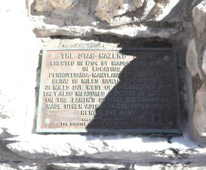
An old plaque is all that tells visitors of the important role the Stargazers Stone had in shaping America.
The duo, according to local lore, consulted a local map, and picked a clear geographical location due west of their Philadelphia location: the forks of the Brandywine Creek in Embreeville. Mason and Dixon spent the winter of 1763-64 at the farm home of John Harlan — a home that still sits at the corner of Rt. 162 and Stargazer Road — and set up a marker point to make astronomical observations just up what would become Stargazer Road. A winter of careful observation of celestial events showed the marker to be just 400 yards south of their marker in Philadelphia. With that in mind, they were able to establish the colonial border 15 miles to the south.
From the work done at Harlan’s farmhouse, the pair were able to establish calculations and measurements enabling them to survey the line to the west, reaching almost to the area south of today’s Pittsburgh. Although both men returned to England in 1768, they left an indelible mark on the United States. The Mason-Dixon Line was used at the boundary between free and slave states in the 1800s — making southern Chester County a key portal for the Underground Railroad. Even today, the line represents the border between North and South, if only culturally.
The Star Gazer Stone is now owned by Chester County and it and the Harlan House are listed on the National Register of Historic Places. The Stone has also been designated a National Historic Civil Engineering Landmark, one of 125 sites in the country.


